Updated August 19, 2023 at 6:10 PM ET
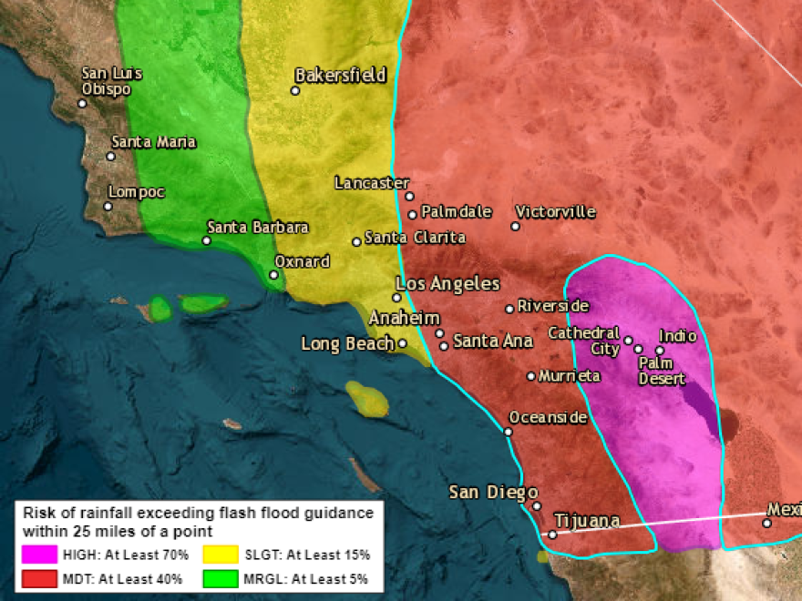
Residents of Southern California are being urged to prepare as torrential rains, flooding and landslides caused by Hurricane Hilary are expected to impact the West Coast and Southwest through the weekend.
The National Weather Center in Miami said in the most recent advisory at 12 a.m. that the maximum sustained wind speed was 85 mph, down from 90 mph hours earlier. The storm was about 90 miles (145 kilometers) south of Punta Eugenia, Mexico, and 450 miles (720 kilometers) from San Diego, California.
The hurricane was downgraded to a Category 1, with maximum sustained winds of 85 mph, The National Weather Center in Miami said in an update. The storm was about 90 miles (145 kilometers) south of Punta Eugenia, Mexico, and 450 miles (720 kilometers) from San Diego, California.
Most of the storm's energy is predicted to cross north of the border with Mexico Sunday night into Monday.
Daniel Swain, a climate scientist at the University of California, Los Angeles, says some inland desert areas could see upward of 5 to 10 inches of rain.
"We're talking about the potential for multiple years worth of precipitation in just two days in some parts of the deserts of southeastern California, southern Nevada and western Arizona," Swain said.
Southern California is under its first-ever tropical storm warning as Hilary approaches. A large section of Mexico's Baja California peninsula was under a hurricane watch or warning on Saturday.
National Weather Service meteorologist Alex Tardy in San Diego told KPBS the last time a hurricane entered San Diego County was 1858, and only a few named storms have ever done the same.
"1976, Kathleen. 1977, Doereen. 1997, Eudora," Tardy lists, "there's not many that we can look back historically that even had a forecast coming right at us."
There was one storm in 1939 that held its tropical storm strength until it got to San Diego, but that's it. This weather is very unusual for the region.
Forecasts call for heavy rain far inland, to places including Palm Springs and the Imperial Valley on the California-Arizona state line.
The National Weather Service says "flash, urban and arroyo flooding is expected, with the potential for rare and dangerous impacts."
There's a lot of concern for the storm's impact on the city of Tijuana. It's a quickly growing city built on a hillside surrounded by canyons. Heavy rainfalls increase the chance of mudslides, which cause more problems and can be deadlier in Tijuana than San Diego.
Even though extreme storms are rare in Southern California, there are preparations in place. Many residents are already prepared for more frequent disasters like wildfires and earthquakes, and have plans in place if they need to leave.
Copyright 2023 NPR. To see more, visit https://www.npr.org.


